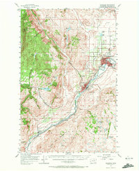
1957 Map of Okanogan
USGS Topo · Published 1972About this map
The Okanogan River carves a deep valley through this landscape, serving as the primary corridor for the Great Northern railroad and the towns of Okanogan and Omak. This mid-century survey illustrates the region's transition into a modern agricultural and transit hub, evidenced by the landing strip, golf course, and drive-in theater located just outside the Omak city limits. To the west, the terrain rises sharply into the high ridges of Neville Ridge and Fox Mountain, where the mining history of the area is represented by the Ruby townsite near Ruby Hill. The map also delineates the northern reaches of the Okanogan Indian Reservation and the Colville Indian Reservation, reflecting the complex jurisdictional history of the river valley. Numerous family-named landmarks like Pogue Mountain and Jackass Butte punctuate the landscape between the river and the western highlands.
Find a feature on this map
62 named features on this map. Tap any name to fly to it.
Don’t see what you’re looking for? This feature index may not catch every label — zoom into the map to look around manually.
Map Details
Editions of this 1957 Okanogan Map
2 editions found
Other maps of this area

1902 · Osoyoos
USGS Topo · 1:125,000

1904 · Osoyoos
USGS Topo · 1:125,000

1905 · Okanogan
USGS Topo · 1:125,000

1906 · Chopaka
USGS Topo · 1:125,000

1950 · Boot Mtn
USGS Topo · 1:62,500

1953 · Omak Lake
USGS Topo · 1:62,500

1954 · Okanogan
USGS Topo · 1:250,000

1956 · Loup Loup
USGS Topo · 1:62,500

1956 · Tiffany Mountain
USGS Topo · 1:62,500

1957 · Okanogan
USGS Topo · 1:62,500