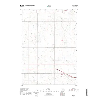
2017 Map of Okaton
USGS Topo · Published 2017About this map
Okaton serves as the focal point of this Jones County landscape, situated along the southern corridor where the local infrastructure follows the historic path of the rail line. The town's grid is anchored by Railway St, reflecting the transportation-driven development common across the South Dakota plains. To the north and west, the terrain is defined by the drainage of Dry Cr, which cuts through the high prairie in a series of branching draws and coulees. The surrounding area is organized by a strict township and range grid, with gravel routes such as 236th St and 258th Ave providing access across the rolling uplands. This 2017 survey illustrates the intersection of modern interstate travel with the established section-line roads and original rail-side settlements that have characterized the region for generations.
Find a feature on this map
18 named features on this map. Tap any name to fly to it.
Don’t see what you’re looking for? This feature index may not catch every label — zoom into the map to look around manually.
Map Details
Editions of this 2017 Okaton Map
This is the sole edition of this map. No revisions or reprints were ever made.
Other maps of this area
1951 · Capa
USGS Topo · 1:24,000
1951 · Stamford SE
USGS Topo · 1:24,000
1951 · Okaton SW
USGS Topo · 1:24,000
1951 · Okaton SE
USGS Topo · 1:24,000
1951 · Capa SE
USGS Topo · 1:24,000
1954 · Midland SE
USGS Topo · 1:24,000
1954 · Pierre
USGS Topo · 1:250,000
1955 · Martin
USGS Topo · 1:250,000
1958 · Pierre
USGS Topo · 1:250,000
1958 · Martin
USGS Topo · 1:250,000