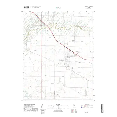
2021 Map of Okawville
USGS Topo · Published 2021About this map
The Kaskaskia River snakes across this portion of southern Illinois, creating a complex corridor of oxbows and backwaters like Halfmoon Lake, Moody Lake, and Benson Slough. At the heart of the landscape, Okawville serves as a central hub for the surrounding agricultural community, where the intersection of W Elm St and N Front St anchors the town grid. The transition from the river bottomlands to the higher ground is marked by Heimanns Hill and the engineered drainage of the Sycamore Drainage Ditch. For those researching family history in the region, the map is remarkably dense with burial sites. Numerous family and denominational grounds are distributed through the countryside, including the Saint Barbara Catholic Cem, the Independent Order of Oddfellows Cem, and Ebenezer Cem, reflecting the deep-rooted settlement patterns of Washington and Clinton counties.
Find a feature on this map
68 named features on this map. Tap any name to fly to it.
Don’t see what you’re looking for? This feature index may not catch every label — zoom into the map to look around manually.
Map Details
Editions of this 2021 Okawville Map
This is the sole edition of this map. No revisions or reprints were ever made.
Other maps of this area

1906 · Breese
USGS Topo · 1:62,500

1907 · Breese
USGS Topo · 1:62,500

1910 · Carlyle
USGS Topo · 1:62,500

1910 · Okawville
USGS Topo · 1:62,500

1931 · Hoyleton
USGS Topo · 1:48,000

1932 · Nashville
USGS Topo · 1:62,500

1936 · Nashville
USGS Topo · 1:62,500

1940 · Okawville
USGS Topo · 1:62,500

1948 · Carlyle
USGS Topo · 1:62,500
1957 · Venedy
USGS Topo · 1:24,000