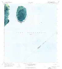
1971 Map of Okeechobee SE
USGS Topo · Published 1976About this map
Lake Okeechobee dominates this orthophotomap, which utilizes aerial imagery from 1970 to provide a clear view of the water's surface and submerged features. Centrally located within the frame is the North Lake Shoal, a large, oval-shaped feature that stands out against the deeper surrounding waters. The map includes an Indefinite Boundary marking the meeting point of several jurisdictions in the open water.
Find a feature on this map
8 named features on this map. Tap any name to fly to it.
Don’t see what you’re looking for? This feature index may not catch every label — zoom into the map to look around manually.
Map Details
Editions of this 1971 Okeechobee SE Map
This is the sole edition of this map. No revisions or reprints were ever made.
Other maps of this area

1952 · Okeechobee NW
USGS Topo · 1:24,000

1952 · Okeechobee
USGS Topo · 1:24,000

1953 · Okeechobee 4 SW
USGS Topo · 1:24,000

1953 · Okeechobee SW
USGS Topo · 1:24,000

1953 · Okeechobee 4 NW
USGS Topo · 1:24,000

1956 · West Palm Beach
USGS Topo · 1:250,000

1956 · Fort Pierce
USGS Topo · 1:250,000

1957 · West Palm Beach
USGS Topo · 1:250,000

1958 · Fort Pierce
USGS Topo · 1:250,000

1958 · West Palm Beach
USGS Topo · 1:250,000