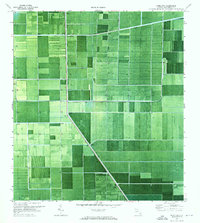
1970 Map of Okeelanta
USGS Topo · Published 1976About this map
Okeelanta sits at the heart of an intensive agricultural landscape in the northern Everglades, defined by a rigid grid of drainage and transport infrastructure. This 1970 orthophotomap, based on aerial photography and planetable surveys, documents the industrial scale of the region's water management system. The landscape is carved by massive waterways including the North New River Canal, New River Canal, and Bolles Canal, supported by numerous Pump stations that regulate the water table for cultivation. Logistics are central to this territory, with the Seaboard Coast Line railroad and a dedicated Landing Strip providing the primary conduits for goods and transit. Notable landmarks such as a Radio Tower and Sewage Disposal site appear as lone structural markers within the repetitive geometry of the expansive fields.
Find a feature on this map
12 named features on this map. Tap any name to fly to it.
Don’t see what you’re looking for? This feature index may not catch every label — zoom into the map to look around manually.
Map Details
Editions of this 1970 Okeelanta Map
2 editions found
Other maps of this area

1956 · West Palm Beach
USGS Topo · 1:250,000

1957 · West Palm Beach
USGS Topo · 1:250,000

1958 · West Palm Beach
USGS Topo · 1:250,000

1970 · Lake Harbor
USGS Topo · 1:24,000

1970 · Belle Glade
USGS Topo · 1:24,000

1970 · Lake Harbor SE
USGS Topo · 1:24,000

1970 · Okeelanta
USGS Topo · 1:24,000

1970 · Shawano
USGS Topo · 1:24,000

1970 · Sixmile Bend
USGS Topo · 1:24,000

1974 · Everglades 1 NW
USGS Topo · 1:24,000