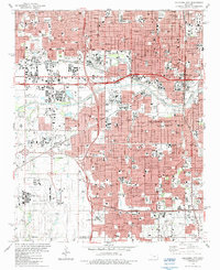
1986 Map of Oklahoma City
USGS Topo · Published 1987About this map
Oklahoma City's mid-1980s urban landscape is defined by its deep integration of civic institutions and transportation infrastructure. The central district is anchored by the State Capitol and the Myriad Convention Center, with the nearby Myriad Gardens providing a landscaped contrast to the dense network of the Santa Fe and Oklahoma Kansas-Texas railroads. Along the North Canadian River, industrial and commercial hubs like the Stockyards and State Fairground sit adjacent to the sweeping path of the Stanley Draper Expressway.
Find a feature on this map
105 named features on this map. Tap any name to fly to it.
Don’t see what you’re looking for? This feature index may not catch every label — zoom into the map to look around manually.
Map Details
Editions of this 1986 Oklahoma City Map
This is the sole edition of this map. No revisions or reprints were ever made.
Other maps of this area

1892 · Moore
USGS Topo · 1:62,500

1892 · Edmond
USGS Topo · 1:62,500

1892 · Kingfisher
USGS Topo · 1:125,000

1893 · Oklahoma City
USGS Topo · 1:62,500

1895 · Kingfisher
USGS Topo · 1:125,000

1898 · Purcell
USGS Topo · 1:125,000

1904 · Chickasha
USGS Topo · 1:125,000

1934 · Crutcho Creek
USGS Topo · 1:24,000

1934 · Moore
USGS Topo · 1:62,500

1935 · Spencer
USGS Topo · 1:24,000