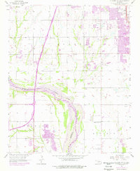
1956 Map of Oklahoma City SE
USGS Topo · Published 1976About this map
The Canadian River meanders across this landscape, serving as the boundary between Cleveland and McClain counties during a period of significant postwar growth. To the north, the expanding city of Moore is shown with its residential developments and key community sites like Moore Cemetery and Resthaven Gardens Cemetery. The map captures a transitional era for local infrastructure, highlighting the Southwest Expressway and the H E Bailey Turnpike as they began to redefine regional travel. Evidence of the mid-century energy economy is visible through the Johnson Oil Field and numerous scattered oil wells. Cultural and educational landmarks, including Pleasant Valley School and the Antioch Ch, provide a grounded view of the social fabric near Newcastle and the western edge of the city near Will Rogers World Airport.
Find a feature on this map
30 named features on this map. Tap any name to fly to it.
Don’t see what you’re looking for? This feature index may not catch every label — zoom into the map to look around manually.
Map Details
Editions of this 1956 Oklahoma City SE Map
3 editions found

Other maps of this area

1892 · Moore
USGS Topo · 1:62,500

1893 · Norman
USGS Topo · 1:62,500

1893 · Oklahoma City
USGS Topo · 1:62,500

1898 · Purcell
USGS Topo · 1:125,000

1904 · Chickasha
USGS Topo · 1:125,000

1925 · Norman NO 2
USGS Topo · 1:24,000

1934 · Crutcho Creek
USGS Topo · 1:24,000

1934 · Moore
USGS Topo · 1:62,500

1936 · Norman
USGS Topo · 1:62,500

1938 · Moore
USGS Topo · 1:62,500