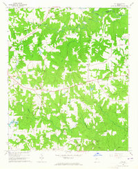
1964 Map of Ola
USGS Topo · Published 1965About this map
Agricultural lands and dense creek networks define this portion of Henry County in the mid-1960s, centered on the crossroads community of Ola. The landscape is heavily marked by its spiritual and educational centers, including the Ola Sch and numerous country churches such as Bethany Ch, Philadelphia Ch, and Antioch Ch. For genealogists, the map is particularly valuable for its documentation of family-named burial grounds and older sites, notably Old Mt Bethel Cem and Old Sharon Cem.
Find a feature on this map
40 named features on this map. Tap any name to fly to it.
Don’t see what you’re looking for? This feature index may not catch every label — zoom into the map to look around manually.
Map Details
Editions of this 1964 Ola Map
Other maps of this area

1888 · Atlanta
USGS Topo · 1:125,000

1890 · Atlanta
USGS Topo · 1:125,000

1892 · Atlanta
USGS Topo · 1:125,000

1895 · Atlanta
USGS Topo · 1:125,000

1896 · Monroe
USGS Topo · 1:125,000

1953 · Atlanta
USGS Topo · 1:250,000

1953 · Athens
USGS Topo · 1:250,000

1957 · Atlanta
USGS Topo · 1:250,000

1958 · Athens
USGS Topo · 1:250,000

1958 · Atlanta
USGS Topo · 1:250,000