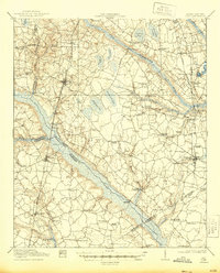
1919 Map of Olar
USGS Topo · Published 1944About this map
The Salkehatchie River and its sister, the Little Salkehatchie River, define the landscape of this 1918 survey of the Lowcountry. A complex web of local transit is visible, from the crossings at Buford Bridge and Rivers Bridge to the rail infrastructure of the Seaboard Line and the Bamberg Ehrhardt and Walterboro RR. The map serves as a detailed record of rural social structures in South Carolina at the end of the Great War, documenting numerous country schools like Oak Ridge School and Sweet Gum School alongside neighborhood landmarks like Bushes Old Mill. Settlements such as Olar, Ehrhardt, and Ulmers appear as established hubs, while family names are preserved through dozens of local churches and chapels, including Kearse Chapel and Rizera Chapel, which anchored these farming communities.
Find a feature on this map
67 named features on this map. Tap any name to fly to it.
Don’t see what you’re looking for? This feature index may not catch every label — zoom into the map to look around manually.
Map Details
Editions of this 1919 Olar Map
3 editions found
Other maps of this area

1918 · Varnville
USGS Topo · 1:62,500

1919 · Olar
USGS Topo · 1:62,500

1919 · Bamberg
USGS Topo · 1:48,000

1919 · Allendale
USGS Topo · 1:62,500

1919 · Cummings
USGS Topo · 1:62,500

1919 · Lodge
USGS Topo · 1:62,500

1920 · Lodge
USGS Topo · 1:48,000

1920 · Bamberg
USGS Topo · 1:62,500

1920 · Peeples
USGS Topo · 1:62,500

1920 · Orangeburg
USGS Topo · 1:48,000