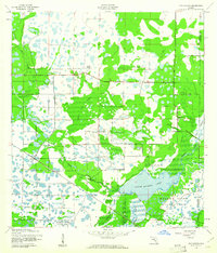
1944 Map of Old Myakka
USGS Topo · Published 1961About this map
Upper Myakka Lake serves as the focal point for this 1944 survey, anchoring a landscape defined by the drainage systems of the Myakka River and Tatum River. This period in Sarasota County history shows the area's transition into protected recreational land within the Myakka River State Park, while still maintaining its deep-rooted ranching and agrarian identity. Settlements like Old Myakka and the aptly named Utopia are situated among a complex network of wetlands, including the Indian Creek Swamp and Vandripe Slough. The presence of the Atlantic Coast Line railroad and local cattle operations such as Ox Bo Ranch and T C Ranch illustrates the region's mid-century economic reliance on both transportation and livestock. The intricate topography reveals how the natural flow of water, from Gunn Slough to Clay Gully, historically dictated the placement of roads and human habitation in this part of Florida.
Find a feature on this map
18 named features on this map. Tap any name to fly to it.
Don’t see what you’re looking for? This feature index may not catch every label — zoom into the map to look around manually.
Map Details
Editions of this 1944 Old Myakka Map
3 editions found
Other maps of this area

1943 · Laurel
USGS Topo · 1:24,000

1944 · Lower Myakka Lake
USGS Topo · 1:31,680

1944 · Verna
USGS Topo · 1:31,680

1944 · Laurel
USGS Topo · 1:31,680

1944 · Lorraine
USGS Topo · 1:31,680

1944 · Miakka
USGS Topo · 1:31,680

1947 · Bee Ridge
USGS Topo · 1:24,000

1956 · Myakka City
USGS Topo · 1:24,000

1956 · Myakka City NW
USGS Topo · 1:24,000

1956 · Murdock NW
USGS Topo · 1:24,000