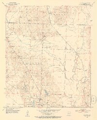
1952 Map of Old Town
USGS Topo · Published 1953About this map
The lowlands of southwestern Arkansas define the landscape around Old Town and the meandering Little Bodcau Creek. This mid-century survey records a rural economy shifting between traditional agriculture and resource extraction, with an active Oil Field and numerous Gravel Pits dotting the terrain. The Kansas City Southern railroad serves as a central artery for the region, passing through small rail points like Dobson Station. For those researching local family history, the map is a primary source for several community anchors, including Turner Chapel, Mt Nebo Ch, and multiple burial sites such as Old Lewisville Cem and Stricklin Cem. The presence of New Meriwether Pond and Barmes Pond suggests a local reliance on water management for agriculture or industry during this period of development.
Find a feature on this map
38 named features on this map. Tap any name to fly to it.
Don’t see what you’re looking for? This feature index may not catch every label — zoom into the map to look around manually.
Map Details
Editions of this 1952 Old Town Map
3 editions found
Other maps of this area

1901 · Gurdon
USGS Topo · 1:125,000

1951 · Patmos
USGS Topo · 1:24,000

1951 · Spring Hill
USGS Topo · 1:24,000

1952 · Garland
USGS Topo · 1:24,000

1952 · Old Town
USGS Topo · 1:24,000

1952 · Lewisville
USGS Topo · 1:24,000

1952 · Boyd Hill
USGS Topo · 1:24,000

1953 · El Dorado
USGS Topo · 1:250,000

1957 · El Dorado
USGS Topo · 1:250,000

1958 · El Dorado
USGS Topo · 1:250,000