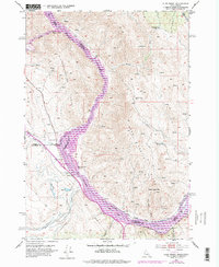
1952 Map of Olds Ferry
USGS Topo · Published 1978About this map
The Snake River carves a deep path through this borderland between Idaho and Oregon, where the 1974 photorevisions reveal the significant hydrological shift caused by the Brownlee Reservoir. This canyon landscape is defined by the high elevations of the Slaughterhouse Range and Dead Indian Ridge, which overlook historic river crossings and industrial routes. Infrastructure is a focal point of the area, featuring the Union Pacific railroad tracks and the Old Oregon Trail Highway tracing the river's western bank. Local history is anchored at Farewell Bend State Park and the former crossing of Olds Ferry (Site). The map also documents resource extraction and markers of early travel, such as Coal Mine Gulch and several Oregon Trail Mon markers, alongside smaller settlements like Darrows and the Crawford Place (Site) on the Idaho side.
Find a feature on this map
33 named features on this map. Tap any name to fly to it.
Don’t see what you’re looking for? This feature index may not catch every label — zoom into the map to look around manually.
Map Details
Editions of this 1952 Olds Ferry Map
3 editions found
Other maps of this area

1950 · Jamieson
USGS Topo · 1:62,500

1951 · Moores Hollow
USGS Topo · 1:24,000

1951 · Moores Hollow
USGS Topo · 1:62,500

1951 · Huntington
USGS Topo · 1:62,500

1952 · Olds Ferry NW
USGS Topo · 1:24,000

1952 · Olds Ferry
USGS Topo · 1:24,000

1952 · Olds Ferry
USGS Topo · 1:62,500

1952 · Olds Ferry SE
USGS Topo · 1:24,000

1955 · Baker
USGS Topo · 1:250,000

1959 · Baker
USGS Topo · 1:250,000