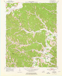
1953 Map of Oldtown
USGS Topo · Published 1976About this map
The Little Sandy River and its tributary Oldtown Creek anchor this mid-century survey of the Greenup and Carter County border. The settlement of Oldtown serves as a focal point near the river's winding path, where numerous small ponds like Brown Pond, Martin Pond, and Fraley Pond dot the bottomlands. The landscape is characterized by a dense network of hollows and ridges, including Bellamy Ridge and Tulga, which separate the various prongs of the drainage system.
Find a feature on this map
102 named features on this map. Tap any name to fly to it.
Don’t see what you’re looking for? This feature index may not catch every label — zoom into the map to look around manually.
Map Details
Editions of this 1953 Oldtown Map
3 editions found

Other maps of this area

1903 · Kenova
USGS Topo · 1:125,000

1904 · Kenova
USGS Topo · 1:125,000

1915 · Garrison
USGS Topo · 1:62,500

1918 · Garrison
USGS Topo · 1:62,500

1926 · Greenup
USGS Topo · 1:48,000

1930 · Greenup
USGS Topo · 1:62,500

1949 · Brushart
USGS Topo · 1:24,000

1950 · Brushart
USGS Topo · 1:24,000

1950 · Grahn
USGS Topo · 1:24,000

1950 · Tygarts Valley
USGS Topo · 1:24,000