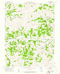
1960 Map of Olean
USGS Topo · Published 1961About this map
Olean sits at the intersection of rail and river commerce along the Missouri Pacific line and the banks of Bluthe Creek. This 1960 field-checked survey reveals a landscape split between the farming townships of Harrison, Burris Fork, and Saline, where small-scale industry like the Tiff Mine and a local Quarry dot the countryside. The map serves as a detailed record for genealogists, capturing numerous family burial grounds including Walker Cem, Gray Cem, and Hill Cem, alongside community centers such as High Point and Rock Enon Ch. To the north, Medlen Creek and the Fish Hatchery illustrate the area's managed water resources. The terrain is defined by the winding course of South Moreau Creek, which serves as a natural boundary between Moniteau and Miller Counties.
Find a feature on this map
23 named features on this map. Tap any name to fly to it.
Don’t see what you’re looking for? This feature index may not catch every label — zoom into the map to look around manually.
Map Details
Editions of this 1960 Olean Map
2 editions found
Other maps of this area

1886 · Jefferson City
USGS Topo · 1:125,000

1888 · Versailles
USGS Topo · 1:125,000

1888 · Tuscumbia
USGS Topo · 1:125,000

1888 · Boonville
USGS Topo · 1:125,000

1893 · Versailles
USGS Topo · 1:125,000

1894 · Tuscumbia
USGS Topo · 1:125,000

1894 · Jefferson City
USGS Topo · 1:125,000

1904 · Eldon
USGS Topo · 1:62,500

1935 · Rocky Mount
USGS Topo · 1:24,000
1935 · Eldon
USGS Topo · 1:24,000