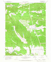
1964 Map of Olinda
USGS Topo · Published 1966About this map
The Dredge Tailings along the northern and central drainage basins reveal a landscape significantly altered by historical mining activity. Large-scale earthmoving is evident along Clear Creek and China Gulch, where the residual mounds of the dredging era dominate the local topography. This industrial legacy sits alongside the agricultural and residential development of Happy Valley, which is defined by an orderly grid of local thoroughfares like Irrigation Ave and Hawthorne Ave.
Find a feature on this map
36 named features on this map. Tap any name to fly to it.
Don’t see what you’re looking for? This feature index may not catch every label — zoom into the map to look around manually.
Map Details
Editions of this 1964 Olinda Map
4 editions found
Other maps of this area

1890 · Red Bluff
USGS Topo · 1:250,000

1894 · Red Bluff
USGS Topo · 1:250,000

1901 · Redding
USGS Topo · 1:125,000

1913 · Weaverville
USGS Topo · 1:125,000

1932 · Olinda
USGS Topo · 1:31,680

1935 · Olinda
USGS Topo · 1:31,680

1944 · Redding
USGS Topo · 1:62,500

1944 · French Gulch
USGS Topo · 1:62,500

1946 · Redding
USGS Topo · 1:62,500

1947 · Anderson
USGS Topo · 1:62,500