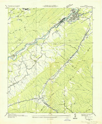
1935 Map of Olinger
USGS Topo · Published 1935About this map
Big Stone Gap serves as the focal point of this 1935 survey, situated at the confluence of the Powell River near Three Forks Island. The landscape is dominated by a series of parallel ridges, including Stone Mountain and Wallen Ridge, which dictate the placement of transportation routes and small mountain settlements. This era shows a heavy reliance on the Southern Railway and the Louisville and Nashville River lines, which snake through narrow gaps like Olinger Gap to serve coal interests such as Stonega Coal No 27. Cultural life is marked by numerous country schools and churches, such as Seminary Sch, Robinette Chapel, and the County Line Sch on the border of Lee and Scott counties. The map captures the industrial and social infrastructure of the Appalachian coal country before modern highway expansion altered these valley corridors.
Find a feature on this map
70 named features on this map. Tap any name to fly to it.
Don’t see what you’re looking for? This feature index may not catch every label — zoom into the map to look around manually.
Map Details
Editions of this 1935 Olinger Map
This is the sole edition of this map. No revisions or reprints were ever made.
Other maps of this area

1894 · Estillville
USGS Topo · 1:125,000

1920 · Wise
USGS Topo · 1:48,000

1921 · Big Stone Gap
USGS Topo · 1:48,000

1921 · Wise
USGS Topo · 1:62,500

1922 · Big Stone Gap
USGS Topo · 1:62,500

1929 · Big Stone Gap
USGS Topo · 1:62,500

1935 · Moggasin
USGS Topo · 1:48,000
1935 · Norton
USGS Topo · 1:24,000
1935 · Appalachia
USGS Topo · 1:24,000

1935 · East Stone Gap
USGS Topo · 1:24,000