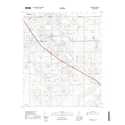
2018 Map of Olive Branch
USGS Topo · Published 2018About this map
Olive Branch and the southern suburban reaches of Memphis anchor this 2018 survey, which straddles the Tennessee Mississippi state line. The landscape is characterized by its transition from the dense road networks of Mineral Wells and Maywood in the north to more dispersed residential clusters like Fairhaven and Cedarview further south. Genealogists will find a high density of burial grounds throughout the quadrangle, including the Castleberry Cem, Clements Cem, and Wiggins Cem, often located near established residential corridors. The natural drainage of the region is defined by Camp Cr and the winding course of the Coldwater River in the southeast corner. Significant infrastructure, such as the Olive Branch Airport and major thoroughfares like Goodman Rd, highlights the area's development as a regional hub for commerce and transportation during the early 21st century.
Find a feature on this map
125 named features on this map. Tap any name to fly to it.
Don’t see what you’re looking for? This feature index may not catch every label — zoom into the map to look around manually.
Map Details
Editions of this 2018 Olive Branch Map
This is the sole edition of this map. No revisions or reprints were ever made.
Other maps of this area

1943 · Collierville
USGS Topo · 1:62,500

1944 · Hernando
USGS Topo · 1:62,500

1948 · Byhalia
USGS Topo · 1:62,500

1953 · Collierville
USGS Topo · 1:50,000

1956 · Blytheville
USGS Topo · 1:250,000

1956 · Tupelo
USGS Topo · 1:250,000

1958 · Tupelo
USGS Topo · 1:250,000

1959 · Blytheville
USGS Topo · 1:250,000

1960 · Bartlett
USGS Topo · 1:62,500

1961 · Bartlett
USGS Topo · 1:62,500