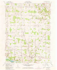
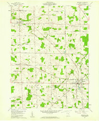
1960 Map of Olivesburg
USGS Topo · Published 1973About this map
The rural landscape of north-central Ohio is marked by the historical division of the Connecticut Western Reserve, where private subdivisions created the distinctive pattern of land lines visible in the northern portion of this survey. Settlements like Adario and Olivesburg anchor the local road network, which includes names like the Olivesburg Fitchville Road and Adario West Road. The southern edge of the map features the waters of Charles Mill Lake and the Black Fork Mohican River, highlighting the region's managed water resources in the mid-20th century.
Find a feature on this map
36 named features on this map. Tap any name to fly to it.
Don’t see what you’re looking for? This feature index may not catch every label — zoom into the map to look around manually.
Map Details
Editions of this 1960 Olivesburg Map
4 editions found
Other maps of this area

1908 · Ashland
USGS Topo · 1:62,500

1908 · New London
USGS Topo · 1:62,500

1915 · Norwalk
USGS Topo · 1:62,500

1915 · Crestline
USGS Topo · 1:62,500

1943 · Crestline
USGS Topo · 1:62,500

1944 · Norwalk
USGS Topo · 1:62,500

1950 · Marion
USGS Topo · 1:250,000

1956 · Toledo
USGS Topo · 1:250,000

1960 · New London
USGS Topo · 1:24,000
1960 · Greenwich
USGS Topo · 1:24,000
Featured Places
- Savannah, OH
- Clear Creek Township, OH
- Butler Township, OH
- Blooming Grove Township, OH
- Ruggles Township, OH