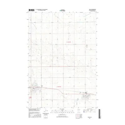
2016 Map of Olivia
USGS Topo · Published 2016About this map
The agricultural plains of Renville County are defined by the grid of the Public Land Survey System and an extensive network of man-made waterways. Drainage infrastructure, including the Judicial Ditch Number Nine and County Ditch Number Sixtyseven, illustrates the engineering required to manage the prairie landscape for cultivation. The neighboring communities of Olivia and Bird Island serve as the primary hubs of activity, anchored by several long-established burial grounds such as the Olivia German Cem, Saint Mary's Cem, and Bird Island Cem.
Find a feature on this map
31 named features on this map. Tap any name to fly to it.
Don’t see what you’re looking for? This feature index may not catch every label — zoom into the map to look around manually.
Map Details
Editions of this 2016 Olivia Map
This is the sole edition of this map. No revisions or reprints were ever made.
Other maps of this area

1952 · Morton
USGS Topo · 1:62,500

1952 · Redwood Falls
USGS Topo · 1:62,500

1953 · New Ulm
USGS Topo · 1:250,000

1957 · New Ulm
USGS Topo · 1:250,000

1957 · Olivia
USGS Topo · 1:62,500

1958 · New Ulm
USGS Topo · 1:250,000

1965 · Danube
USGS Topo · 1:24,000
1965 · Blomkest
USGS Topo · 1:24,000

1967 · New Ulm
USGS Topo · 1:250,000
1982 · Olivia SE
USGS Topo · 1:24,000
Featured Places
- Olivia, MN
- Bird Island, MN
- Meadowcrest Estates Mobile Home Park, Olivia
- Renville County, MN
- United States