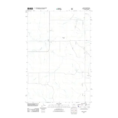
2011 Map of Ollie
USGS Topo · Published 2011About this map
Ollie sits at the heart of this high-plains landscape where the drainage patterns of several seasonal watercourses converge. In this 2011 survey, the rural character of Fallon County is defined by the winding paths of Beaver Creek and its tributary, the Fork of Beaver Creek, which thread through the prairie alongside Mud Creek and Horse Creek. The terrain is marked by the Hat Creek Breaks, a distinctive topographical feature indicating the transition between flat rangeland and more eroded creek valleys. Local ranching life is grounded by named properties like the Tennant Ranch in the southeast. A grid of section roads, including Carlyle Rd and Old 16 Rd, provides the primary infrastructure for this remote community, connecting isolated homesteads to the small settlement of Ollie during the early 21st century.
Find a feature on this map
16 named features on this map. Tap any name to fly to it.
Don’t see what you’re looking for? This feature index may not catch every label — zoom into the map to look around manually.
Map Details
Editions of this 2011 Ollie Map
This is the sole edition of this map. No revisions or reprints were ever made.
Other maps of this area

1953 · Miles City
USGS Topo · 1:250,000

1953 · Dickinson
USGS Topo · 1:250,000

1957 · Dickinson
USGS Topo · 1:250,000

1957 · Miles City
USGS Topo · 1:250,000

1958 · Miles City
USGS Topo · 1:250,000

1980 · Golva
USGS Topo · 1:24,000

1980 · Pretty Butte
USGS Topo · 1:24,000

1980 · Belfield
USGS Topo · 1:100,000

1981 · Baker
USGS Topo · 1:100,000
1981 · Morris Butte
USGS Topo · 1:24,000