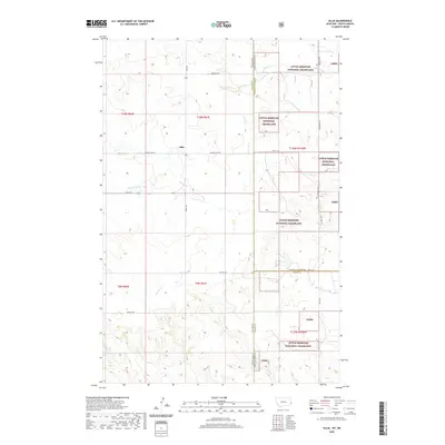
2020 Map of Ollie
USGS Topo · Published 2020About this map
The small settlement of Ollie sits at the heart of this high-plains landscape, positioned near the Montana-North Dakota state line. This 2020 survey illustrates a region defined by its drainage systems, where Beaver Creek and its tributary, the Fork of Beaver Creek, carve through the terrain alongside Bull Run Creek and Cottonwood Creek. The geography transitions into the protected federal lands of the Little Missouri National Grassland to the east, marked by the administrative acronym Lmng. Local transit and historical routes are clearly delineated, including the cross-border Mon Dak Trail and the evocatively named Beaver Slide Road. The intersection of multiple county lines, including Fallon, Golden Valley, and Slope, underscores the jurisdictional complexity of this rural borderland where livestock grazing and resource management shape the modern character of the land.
Find a feature on this map
29 named features on this map. Tap any name to fly to it.
Don’t see what you’re looking for? This feature index may not catch every label — zoom into the map to look around manually.
Map Details
Editions of this 2020 Ollie Map
This is the sole edition of this map. No revisions or reprints were ever made.
Other maps of this area

1953 · Miles City
USGS Topo · 1:250,000

1953 · Dickinson
USGS Topo · 1:250,000

1957 · Dickinson
USGS Topo · 1:250,000

1957 · Miles City
USGS Topo · 1:250,000

1958 · Miles City
USGS Topo · 1:250,000

1980 · Golva
USGS Topo · 1:24,000

1980 · Pretty Butte
USGS Topo · 1:24,000

1980 · Belfield
USGS Topo · 1:100,000

1981 · Baker
USGS Topo · 1:100,000
1981 · Morris Butte
USGS Topo · 1:24,000