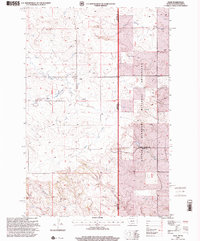
1997 Map of Ollie
USGS Topo · Published 2001About this map
The small community of Ollie sits at the center of this late 1990s landscape, serving as a focal point for ranching and homesteads along the border of Montana and North Dakota. This high plains environment is defined by a dense network of seasonal drainages, including Beaver Creek, Cottonwood Creek, and Mud Creek, which carve through the undulating terrain. A significant portion of the eastern map area falls within the Little Missouri National Grassland, where the land is managed for conservation and public grazing. This survey provides a precise record of rural life, marking isolated structures, a local Cem, and a Scoria Pit used for road material. The presence of the Fifteenth Guide Meridian East indicates the importance of these foundational surveys in organizing the vast township and range system of the American West.
Find a feature on this map
18 named features on this map. Tap any name to fly to it.
Don’t see what you’re looking for? This feature index may not catch every label — zoom into the map to look around manually.
Map Details
Editions of this 1997 Ollie Map
This is the sole edition of this map. No revisions or reprints were ever made.
Other maps of this area

1953 · Miles City
USGS Topo · 1:250,000

1953 · Dickinson
USGS Topo · 1:250,000

1957 · Dickinson
USGS Topo · 1:250,000

1957 · Miles City
USGS Topo · 1:250,000

1958 · Miles City
USGS Topo · 1:250,000

1980 · Golva
USGS Topo · 1:24,000

1980 · Pretty Butte
USGS Topo · 1:24,000

1980 · Belfield
USGS Topo · 1:100,000

1981 · Baker
USGS Topo · 1:100,000
1981 · Morris Butte
USGS Topo · 1:24,000