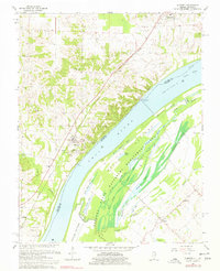
1967 Map of Olmsted
USGS Topo · Published 1977About this map
The Ohio River dominates this landscape where Illinois and Kentucky meet, serving as both a state boundary and a vital artery for the region's mid-century commerce. Near Olmsted, the river's navigational importance is marked by Lock and Dam No 53 and historic river access points like Caledonia Landing. On the Illinois side, the New York Central railroad parallels the river through the settlements of Grand Chain and Levings, while the Kentucky shoreline opens into the vast Oscar Bottoms. This low-lying area is characterized by an intricate network of wetlands, including Shelby Lake, Mud Lake, and Goose Pond, much of which is preserved within the Ballard State Waterfowl Management Area. Numerous small family and community burial grounds, such as Masonic Cem and Lyerly Cem, are scattered throughout the agricultural uplands, providing a detailed record of local genealogy.
Find a feature on this map
53 named features on this map. Tap any name to fly to it.
Don’t see what you’re looking for? This feature index may not catch every label — zoom into the map to look around manually.
Map Details
Editions of this 1967 Olmsted Map
2 editions found
Other maps of this area

1918 · Vienna
USGS Topo · 1:62,500

1919 · Vienna
USGS Topo · 1:62,500

1920 · Dongola
USGS Topo · 1:62,500

1923 · Dongola
USGS Topo · 1:62,500

1928 · La Center
USGS Topo · 1:62,500

1931 · Cairo
USGS Topo · 1:62,500

1932 · La Center
USGS Topo · 1:62,500

1933 · Cairo
USGS Topo · 1:62,500

1939 · Cairo
USGS Topo · 1:62,500

1942 · Vienna
USGS Topo · 1:62,500