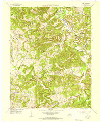
1954 Map of Olney
USGS Topo · Published 1955About this map
Tradewater River meanders through the northeast corner of this mid-century survey, defining the boundary between Caldwell and Hopkins counties. The landscape is characterized by a dense network of ridges and hollows, where small agricultural settlements like Olney and Lewistown are tucked between landmarks such as Castleberry Ridge and Hickory Ridge. A distinct human imprint is seen in the rural infrastructure of the 1950s, including the Lookout Tower on Morse Ridge and the Pipe Line cutting through the western hills.
Find a feature on this map
66 named features on this map. Tap any name to fly to it.
Don’t see what you’re looking for? This feature index may not catch every label — zoom into the map to look around manually.
Map Details
Editions of this 1954 Olney Map
This is the sole edition of this map. No revisions or reprints were ever made.
Other maps of this area

1907 · Earlington
USGS Topo · 1:48,000

1908 · Princeton
USGS Topo · 1:62,500

1909 · Dawson Springs
USGS Topo · 1:48,000

1909 · Earlington
USGS Topo · 1:62,500

1909 · Providence
USGS Topo · 1:62,500

1910 · Princeton
USGS Topo · 1:62,500

1911 · Dawson Springs
USGS Topo · 1:62,500

1953 · Dawson Springs SW
USGS Topo · 1:24,000

1954 · Evansville
USGS Topo · 1:250,000
1954 · Shady Grove
USGS Topo · 1:24,000