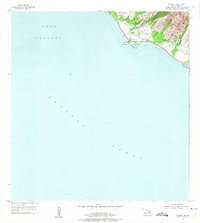
1955 Map of Olowalu
USGS Topo · Published 1975About this map
Sugar industry remnants and ancient Hawaiian sites characterize the West Maui coastline captured in this mid-century survey. The settlement of Olowalu serves as the focal point, where the presence of Mill (Ruins) and the nearby Olowalu Wharf point to the area's agricultural past. Inland, the landscape is defined by water management infrastructure essential for the cane fields, including the Olowalu Shaft (Well) and several Ukumehame Reservoirs. Cultural significance is noted by the inclusion of a Heiau and a local Cem, reflecting both pre-contact history and the plantation era. The narrow strip of habitable land between the steep mountain slopes and the Coral Reef is traversed by the Honoapiilani Highway, connecting the small clusters at Mopua and Awalua. This map documents a period when Maui's leeward coast still bore the heavy physical architecture of the sugar mills before late-twentieth-century transitions.
Find a feature on this map
18 named features on this map. Tap any name to fly to it.
Don’t see what you’re looking for? This feature index may not catch every label — zoom into the map to look around manually.
Map Details
Editions of this 1955 Olowalu Map
2 editions found
Other maps of this area

1929 · Kahoolawe
USGS Topo · 1:62,500

1954 · Maui
USGS Topo · 1:250,000

1954 · Maalaea
USGS Topo · 1:24,000

1955 · Olowalu
USGS Topo · 1:24,000

1955 · Wailuku
USGS Topo · 1:24,000

1956 · Lahaina
USGS Topo · 1:24,000

1966 · Maui
USGS Topo · 1:250,000

1974 · Maui
USGS Topo · 1:250,000

1977 · Wailuku
USGS Topo · 1:24,000
1978 · Lahaina
USGS Topo · 1:24,000