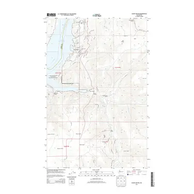
2013 Map of Olsen Canyon
USGS Topo · Published 2013About this map
Seven Bays sits along the shoreline of Franklin D Roosevelt Lake, serving as a primary focal point for human activity in this portion of the Lake Roosevelt National Recreation Area. The landscape is defined by the sharp transition between the massive impoundment of the Columbia River and the deeply incised basalt drainages of the Columbia Plateau. Named canyons like Olsen Canyon, Snook Canyon, and Trinkle Canyon cut through the high ground, while more level areas like Swede Flats and Bachelor Prairie supported earlier settlement patterns. The presence of the 7 Bays Airport and the residential road network near the water contrast with the more traditional agricultural and ranching layout found further inland near Egypt. Along the southern reaches of the lake, Hawk Creek Falls marks a significant hydrological transition where Hawk Creek meets the reservoir's edge.
Find a feature on this map
59 named features on this map. Tap any name to fly to it.
Don’t see what you’re looking for? This feature index may not catch every label — zoom into the map to look around manually.
Map Details
Editions of this 2013 Olsen Canyon Map
This is the sole edition of this map. No revisions or reprints were ever made.
Other maps of this area

1948 · Lincoln
USGS Topo · 1:62,500

1948 · Turtle Lake
USGS Topo · 1:62,500

1950 · Lincoln
USGS Topo · 1:62,500

1950 · Turtle Lake
USGS Topo · 1:62,500

1953 · Ritzville
USGS Topo · 1:250,000

1959 · Ritzville
USGS Topo · 1:250,000

1965 · Ritzville
USGS Topo · 1:250,000

1969 · Telford
USGS Topo · 1:24,000

1969 · Rocklyn
USGS Topo · 1:24,000
1969 · Davenport
USGS Topo · 1:24,000