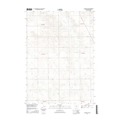
2015 Map of Olsonville NW
USGS Topo · Published 2015About this map
Antelope Cr meanders through the heart of this Todd County landscape, defining the topography of the Rosebud region. The 2015 survey reveals a disciplined grid of rural infrastructure, where routes like Lakeview Rd and 270th Ave carve the terrain into established townships. The section lines, such as those defining t37n r28w and t38n r29w, underscore the enduring legacy of the Public Land Survey System in organizing the northern Great Plains. This map is particularly useful for understanding the exact placement of property boundaries and local thoroughfares like 288th St and 295th St during the early 21st century. The relative lack of dense development highlights a preservation of open space and the natural drainage patterns of the creek bed, offering a clear record of the area's physical geography before modern shifts in land usage.
Find a feature on this map
21 named features on this map. Tap any name to fly to it.
Don’t see what you’re looking for? This feature index may not catch every label — zoom into the map to look around manually.
Map Details
Editions of this 2015 Olsonville NW Map
This is the sole edition of this map. No revisions or reprints were ever made.
Other maps of this area

1955 · Martin
USGS Topo · 1:250,000

1958 · Martin
USGS Topo · 1:250,000

1969 · Mission
USGS Topo · 1:24,000

1969 · Soldier Creek SE
USGS Topo · 1:24,000

1969 · Olsonville NW
USGS Topo · 1:24,000

1969 · Rosebud
USGS Topo · 1:24,000

1969 · Olsonville SW
USGS Topo · 1:24,000

1969 · St. Francis SE
USGS Topo · 1:24,000

1982 · Olsonville
USGS Topo · 1:24,000

1982 · Olsonville SE
USGS Topo · 1:24,000