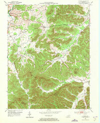
1953 Map of Olympia
USGS Topo · Published 1973About this map
Bourbon Furnace (Ruins) stands as a silent witness to the early industrial history of Bath County, located along the winding course of Polk Creek. By the early 1950s, the community of Olympia served as a key point on the Chesapeake and Ohio railroad, which cut through the northern portion of the quadrangle. The map captures a transition from the structured rail corridors to the deeply dissected terrain of the Cumberland National Forest, where the landscape is defined by prominent knobs like Mount Olympus and North Knob. Local life is recorded through family landmarks and small rural institutions, including the Jackson Cem, Shrout Cem, and several schoolhouses like Pine Grove Sch. The rugged boundary between Bath and Menifee counties follows the high ridges, separating the many drainages such as Slate Creek and Lick Creek that carve through this section of the Kentucky hills.
Find a feature on this map
49 named features on this map. Tap any name to fly to it.
Don’t see what you’re looking for? This feature index may not catch every label — zoom into the map to look around manually.
Map Details
Editions of this 1953 Olympia Map
2 editions found
Other maps of this area

1892 · Beattyville
USGS Topo · 1:125,000

1929 · Salt Lick
USGS Topo · 1:62,500

1934 · Salt Lick
USGS Topo · 1:62,500

1952 · Preston
USGS Topo · 1:24,000

1952 · Owingsville
USGS Topo · 1:24,000

1952 · Scranton
USGS Topo · 1:24,000

1952 · Frenchburg
USGS Topo · 1:24,000

1952 · Means
USGS Topo · 1:24,000

1953 · Olympia
USGS Topo · 1:24,000

1953 · Farmers
USGS Topo · 1:24,000