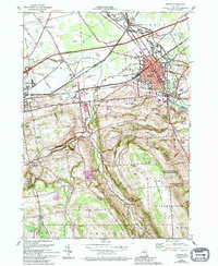
1955 Map of Oneida
USGS Topo · Published 1994About this map
The city of Oneida serves as a central hub in this mid-century landscape, positioned where the Oneida Lake Canal and Old Erie Canal State Park intersect with a complex web of transportation routes. To the west, Wampsville and Lenox Basin follow the historic canal alignment, while southern terrain rises toward West Stockbridge Hill. This area is defined by its transition from industrial canal-side settlements to the upland farms of Clockville and Merrillsville.
Find a feature on this map
55 named features on this map. Tap any name to fly to it.
Don’t see what you’re looking for? This feature index may not catch every label — zoom into the map to look around manually.
Map Details
Editions of this 1955 Oneida Map
4 editions found
Other maps of this area

1895 · Chittenango
USGS Topo · 1:62,500

1895 · Oneida
USGS Topo · 1:62,500

1897 · Cazenovia
USGS Topo · 1:62,500

1898 · Oneida
USGS Topo · 1:62,500

1898 · Chittenango
USGS Topo · 1:62,500

1899 · Cazenovia
USGS Topo · 1:62,500

1902 · Chittenango
USGS Topo · 1:62,500

1902 · Morrisville
USGS Topo · 1:62,500

1902 · Oneida
USGS Topo · 1:62,500

1939 · Oneida
USGS Topo · 1:62,500