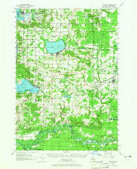
1956 Map of Onekama
USGS Topo · Published 1965About this map
Bear Lake and the coastal waters of Lake Michigan define this mid-1950s landscape of northwest Michigan. The settlement pattern reflects a mix of lakeside resort life and inland agriculture, centered on towns like Onekama on Portage Lake and Arcadia further north. Industrial and transport connections are evident through the Chesapeake and Ohio Railroad, which cuts through the region near Onekama Junction and Kaleva.
Find a feature on this map
112 named features on this map. Tap any name to fly to it.
Don’t see what you’re looking for? This feature index may not catch every label — zoom into the map to look around manually.
Map Details
Editions of this 1956 Onekama Map
3 editions found
Other maps of this area

1933 · Peacock NW
USGS Topo · 1:31,680

1954 · Traverse City
USGS Topo · 1:250,000

1954 · Manitowoc
USGS Topo · 1:250,000

1956 · Onekama
USGS Topo · 1:62,500

1956 · Bar Lake
USGS Topo · 1:62,500

1956 · Thompsonville
USGS Topo · 1:62,500

1956 · Frankfort
USGS Topo · 1:62,500

1957 · Freesoil
USGS Topo · 1:62,500

1957 · Copemish
USGS Topo · 1:62,500

1957 · Wellston
USGS Topo · 1:62,500