
1976 Map of Onekama NW
USGS Topo · Published 1976About this map
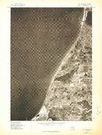
The shoreline of Lake Michigan and the expansive waters of Bear Lake anchor this 1976 orthophotoquad of Manistee County. Unlike traditional line-drawn maps, this aerial imagery provides a direct photographic view of the landscape's transformation during the mid-1970s. The village of Arcadia is visible near the northern coast, while the settlement of Pierport sits further south along the lakefront. Inland, the community of Bear Lake borders its namesake water body, surrounded by a distinct patchwork of agricultural fields and woodlots. Smaller locales like Malcolm are captured within the rural grid, illustrating the distribution of farmsteads and rural development that characterizes this fruit-growing region of Western Michigan. The imagery reveals the intricate road networks and property lines that defined the area's social and economic geography just before the modern era of expansion.
Find a feature on this map
6 named features on this map. Tap any name to fly to it.
Don’t see what you’re looking for? This feature index may not catch every label — zoom into the map to look around manually.
Map Details
Editions of this 1976 Onekama NW Map
This is the sole edition of this map. No revisions or reprints were ever made.
Other maps of this area

1954 · Manitowoc
USGS Topo · 1:250,000

1956 · Onekama
USGS Topo · 1:62,500

1956 · Bar Lake
USGS Topo · 1:62,500

1956 · Frankfort
USGS Topo · 1:62,500

1958 · Manitowoc
USGS Topo · 1:250,000

1976 · Frankfort SE
USGS Topo · 1:24,000

1976 · Onekama SE
USGS Topo · 1:24,000

1976 · Frankfort SW
USGS Topo · 1:24,000

1976 · Onekama SW
USGS Topo · 1:24,000
1976 · Bar Lake SE
USGS Topo · 1:24,000
Featured Places
- Arcadia, Arcadia Township
- Bear Lake, Bear Lake Township
- Arcadia Township, MI
- Malcolm, Pleasanton Township
- Onekama Township, MI