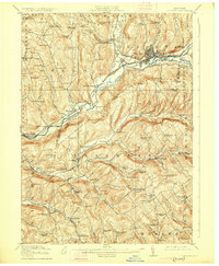
1918 Map of Oneonta
USGS Topo · Published 1926About this map
Oneonta serves as the primary rail and river hub in this 1915 survey, where the Susquehanna Division of the Delaware and Hudson railroad tracks the course of the Susquehanna River. The landscape is defined by the deep valleys of Otego Creek and Ouleout Creek, supporting a network of small agricultural settlements and rural school districts. To the south, the New York Ontario and Western line cuts through the hills to reach Franklin Depot and Woodford Northfield Sta. One distinctive industrial landmark is the Arctic Creamery, situated near the headwaters of a creek branch, reflecting the dairy economy of Delaware and Otsego counties during this era. Genealogists will find a high density of named schoolhouses, such as Green Street School and Fowler School, which anchor the small valley communities.
Find a feature on this map
98 named features on this map. Tap any name to fly to it.
Don’t see what you’re looking for? This feature index may not catch every label — zoom into the map to look around manually.
Map Details
Editions of this 1918 Oneonta Map
3 editions found

Other maps of this area

1907 · Cooperstown
USGS Topo · 1:62,500

1909 · Cooperstown
USGS Topo · 1:62,500

1909 · Delhi
USGS Topo · 1:62,500

1910 · Hartwick
USGS Topo · 1:62,500

1910 · New Berlin
USGS Topo · 1:62,500

1911 · Delhi
USGS Topo · 1:62,500

1912 · New Berlin
USGS Topo · 1:62,500

1912 · Hartwick
USGS Topo · 1:62,500

1915 · Oneonta
USGS Topo · 1:62,500

1915 · Unadilla
USGS Topo · 1:62,500