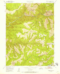
1950 Map of Onion Valley
USGS Topo · Published 1958About this map
Middle Fork Feather River and the South Fork Feather River cut through this gold-rich section of the Sierra Nevada, where the 1950 landscape is defined by its mining heritage. Numerous inactive sites such as the White Pine Chrome Mine and the Feather Fork Mine are scattered across the terrain, alongside former settlements like Onion Valley and Last Chance. The map documents the intricate network of water management and resource extraction, from the Onion Valley Reservoir to Placer Diggings and Monitor Flat. Small outposts and camps like Barkers Cabin and McCarthy Bar are preserved here, tucked away from the higher elevations of Gibsonville Ridge and peaks like Fowler Peak. This survey provides a precise record of the infrastructure supporting the Plumas National Forest, including the Cleghorn Bar Road and various trails that connected these remote mountain reaches during the mid-century.
Find a feature on this map
82 named features on this map. Tap any name to fly to it.
Don’t see what you’re looking for? This feature index may not catch every label — zoom into the map to look around manually.
Map Details
Editions of this 1950 Onion Valley Map
3 editions found
Other maps of this area

1888 · Bidwell Bar
USGS Topo · 1:125,000

1891 · Bidwell Bar
USGS Topo · 1:125,000

1891 · Downieville
USGS Topo · 1:125,000

1893 · Bidwell Bar
USGS Topo · 1:125,000

1893 · Downieville
USGS Topo · 1:125,000

1895 · Bidwell Bar
USGS Topo · 1:125,000

1895 · Downieville
USGS Topo · 1:125,000

1896 · Downieville
USGS Topo · 1:125,000

1897 · Bidwell Bar
USGS Topo · 1:125,000

1897 · Downieville
USGS Topo · 1:125,000