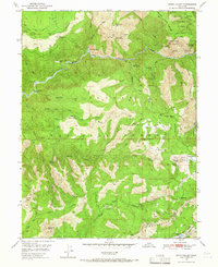
1950 Map of Onion Valley
USGS Topo · Published 1966About this map
The Middle Fork Feather River carves a deep path through this section of the Plumas National Forest, where a legacy of gold and chrome mining is recorded in the landscape. By the mid-20th century, many of the active sites had transitioned to inactive status, yet the map meticulously preserves their locations, including the White Pine Chrome Mine and Egbert Mines. The area around Rich Bar and McCarthy Bar along the river highlights early river-bottom claims, while higher elevations show the extensive Onion Valley Diggings and the now-vacant Onion Valley Site. This 1950 field-checked survey captures the transition from a resource-extraction economy to one focused on forest management, visible in the Feather River Experimental Forest and the development of the Onion Valley Reservoir.
Find a feature on this map
68 named features on this map. Tap any name to fly to it.
Don’t see what you’re looking for? This feature index may not catch every label — zoom into the map to look around manually.
Map Details
Editions of this 1950 Onion Valley Map
3 editions found
Other maps of this area

1888 · Bidwell Bar
USGS Topo · 1:125,000

1891 · Bidwell Bar
USGS Topo · 1:125,000

1891 · Downieville
USGS Topo · 1:125,000

1893 · Bidwell Bar
USGS Topo · 1:125,000

1893 · Downieville
USGS Topo · 1:125,000

1895 · Bidwell Bar
USGS Topo · 1:125,000

1895 · Downieville
USGS Topo · 1:125,000

1896 · Downieville
USGS Topo · 1:125,000

1897 · Bidwell Bar
USGS Topo · 1:125,000

1897 · Downieville
USGS Topo · 1:125,000