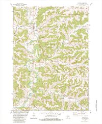
1983 Map of Ontario
USGS Topo · Published 1984About this map
Wildcat Mountain State Park anchors the center of this 1980s landscape, where the deeply carved valleys of the Driftless Area dictate the pattern of settlement. The Kickapoo River meanders south through the western edge of the quadrangle, passing the village of Ontario and the smaller community of Rockton. The topography is defined by a dense network of coulees and hollows, including Cheyenne Valley and Warner Creek, which reveal the area's intricate drainage system.
Find a feature on this map
58 named features on this map. Tap any name to fly to it.
Don’t see what you’re looking for? This feature index may not catch every label — zoom into the map to look around manually.
Map Details
Editions of this 1983 Ontario Map
This is the sole edition of this map. No revisions or reprints were ever made.
Other maps of this area

1916 · Tomah
USGS Topo · 1:62,500

1919 · Kendall
USGS Topo · 1:62,500

1921 · Kendall
USGS Topo · 1:62,500

1926 · La Farge
USGS Topo · 1:62,500

1927 · Hillsboro
USGS Topo · 1:62,500

1949 · Tomah
USGS Topo · 1:62,500

1958 · La Crosse
USGS Topo · 1:250,000

1961 · La Crosse
USGS Topo · 1:250,000

1962 · Kendall
USGS Topo · 1:62,500

1965 · La Crosse
USGS Topo · 1:250,000