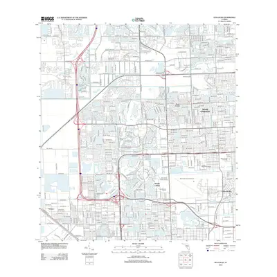
2012 Map of Opa-locka
USGS Topo · Published 2012About this map
Miami Gardens and Miami Lakes anchor this suburban landscape in northern Miami-Dade County, defined by its intricate network of man-made lakes and major transportation corridors. The map reveals a highly structured residential environment where planned communities like Royal Country and Billy Graham Farm Village sit adjacent to large-scale industrial and utility footprints, including the North Dade Landfill and Opa-Locka Executive Airport. Education and institutional land use are prominent, represented by Saint Thomas University and Florida Memorial College. The influence of water management is everywhere, from the Snake-Cr-Canal to neighborhood water bodies such as Lake Steven, Lake Ruth, and Lake Tahoe, which serve as both aesthetic centerpieces for housing developments and functional components of the region's drainage system.
Find a feature on this map
34 named features on this map. Tap any name to fly to it.
Don’t see what you’re looking for? This feature index may not catch every label — zoom into the map to look around manually.
Map Details
Editions of this 2012 Opa-locka Map
This is the sole edition of this map. No revisions or reprints were ever made.
Other maps of this area

1947 · North Miami
USGS Topo · 1:24,000

1949 · Opalocka
USGS Topo · 1:24,000

1949 · Fort Lauderdale South
USGS Topo · 1:24,000

1950 · Hialeah
USGS Topo · 1:24,000

1950 · Miami
USGS Topo · 1:24,000

1950 · North Miami
USGS Topo · 1:24,000

1956 · Miami
USGS Topo · 1:250,000

1956 · West Palm Beach
USGS Topo · 1:250,000

1957 · West Palm Beach
USGS Topo · 1:250,000

1958 · West Palm Beach
USGS Topo · 1:250,000