
1962 Map of Opal City
USGS Topo · Published 1963About this map
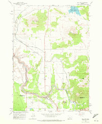
Crooked River carves a deep, winding course through this Central Oregon landscape, defining the boundary between Jefferson and Deschutes counties. The early 1960s terrain is characterized by the massive presence of volcanic landforms, notably Juniper Butte and Haystack Butte, which rise sharply above the high desert floor. The vital role of water management in this arid region is evident through the extensive irrigation network, including the North Unit Main Canal and the Haystack Reservoir, supporting the local agricultural economy around the settlement of Opal City.
Find a feature on this map
24 named features on this map. Tap any name to fly to it.
Don’t see what you’re looking for? This feature index may not catch every label — zoom into the map to look around manually.
Map Details
Editions of this 1962 Opal City Map
2 editions found
Other maps of this area

1926 · Bend
USGS Topo · 1:125,000

1928 · Madras
USGS Topo · 1:125,000

1929 · Bend
USGS Topo · 1:125,000

1931 · Madras
USGS Topo · 1:125,000

1955 · Bend
USGS Topo · 1:250,000

1957 · Bend
USGS Topo · 1:250,000

1958 · Bend
USGS Topo · 1:250,000

1961 · Redmond
USGS Topo · 1:24,000

1962 · Oneil
USGS Topo · 1:24,000
1962 · Redmond
USGS Topo · 1:24,000