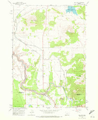
1962 Map of Opal City
USGS Topo · Published 1972About this map
Opal City and the surrounding high desert terrain are defined by the critical infrastructure required to manage water and transport in the early 1960s. The North Unit Main Canal and its associated Flume systems wind through the landscape, supporting agriculture near Haystack Reservoir. This era shows the Oregon Trunk railroad corridor providing essential transit through the region, paralleling the steep canyon walls of the Crooked River. The mapping captures a distinct transition at the southern edge, where the Jefferson Co - Deschutes Co line crosses near the dramatic vistas of Peter Skene Ogden State Park and Smith Rock State Park. Notable natural landmarks like Juniper Butte and Haystack Butte anchor the topography, while smaller features like the Sherwood Canyon Siphon illustrate the engineering efforts used to move water across these volcanic plains.
Find a feature on this map
21 named features on this map. Tap any name to fly to it.
Don’t see what you’re looking for? This feature index may not catch every label — zoom into the map to look around manually.
Map Details
Editions of this 1962 Opal City Map
2 editions found
Other maps of this area

1926 · Bend
USGS Topo · 1:125,000

1928 · Madras
USGS Topo · 1:125,000

1929 · Bend
USGS Topo · 1:125,000

1931 · Madras
USGS Topo · 1:125,000

1955 · Bend
USGS Topo · 1:250,000

1957 · Bend
USGS Topo · 1:250,000

1958 · Bend
USGS Topo · 1:250,000

1961 · Redmond
USGS Topo · 1:24,000

1962 · Opal City
USGS Topo · 1:24,000

1962 · Oneil
USGS Topo · 1:24,000