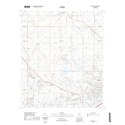
2020 Map of Opelika West
USGS Topo · Published 2020About this map
Auburn and Opelika anchor this modern survey of Lee County, documenting the suburban growth and historical landmarks between these two major Alabama cities. The landscape is defined by the winding course of Sougahatchee Cr, which feeds into Sougahatchee Lake and Jackson Lake. Historical settlement patterns are visible in outlying communities like Oak Bowery and Farmville, where old family names persist in landmarks such as Oak Bowery Cem and Allen Cem. The map illustrates the expansion of residential developments and transportation corridors, including the Lafayette Pkwy, while preserving the locations of long-standing community centers like Pepperell. From the northern reaches of North Auburn to the industrial and commercial intersections near The Bottle, this sheet provides a detailed look at the contemporary geography of the eastern Alabama Piedmont region.
Find a feature on this map
196 named features on this map. Tap any name to fly to it.
Don’t see what you’re looking for? This feature index may not catch every label — zoom into the map to look around manually.
Map Details
Editions of this 2020 Opelika West Map
This is the sole edition of this map. No revisions or reprints were ever made.
Other maps of this area

1906 · Dadeville
USGS Topo · 1:125,000

1907 · Opelika
USGS Topo · 1:125,000

1909 · Opelika
USGS Topo · 1:125,000

1955 · Phenix City
USGS Topo · 1:250,000

1957 · Phenix City
USGS Topo · 1:250,000

1958 · Phenix City
USGS Topo · 1:250,000

1970 · Opelika East
USGS Topo · 1:24,000

1971 · Waverly
USGS Topo · 1:24,000

1971 · Parkers Crossroads
USGS Topo · 1:24,000
1971 · Cusseta
USGS Topo · 1:24,000