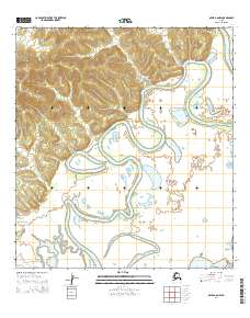
2014 Map of Ophir A-6 NW
USGS Topo · Published 2014About this map
The Innoko River dominates this landscape, its complex series of meanders and oxbow lakes carving through the heart of the Alaska interior. The river's winding path through the t26s r1w and t27s r1w township boundaries illustrates a highly dynamic riparian environment where the waterway frequently shifts its course across the low-lying terrain. In the southeastern portion of the map, the Iditarod River makes a brief appearance, signaling the proximity of another vital historical transportation corridor. This 2014 survey by the U.S. Geological Survey and the National Hydrography Dataset provides a precise record of these shifting western Alaskan waterways, highlighting the intricate natural drainage patterns that have historically dictated travel and access in this region.
Find a feature on this map
8 named features on this map. Tap any name to fly to it.
Don’t see what you’re looking for? This feature index may not catch every label — zoom into the map to look around manually.
Map Details
Editions of this 2014 Ophir A-6 NW Map
This is the sole edition of this map. No revisions or reprints were ever made.
Other maps of this area

1951 · Ophir
USGS Topo · 1:250,000

1951 · Unalakleet
USGS Topo · 1:250,000

1952 · Unalakleet A-1
USGS Topo · 1:63,360

1952 · Unalakleet B-1
USGS Topo · 1:63,360

1952 · Unalakleet
USGS Topo · 1:250,000

1954 · Ophir A-6
USGS Topo · 1:63,360
1954 · Ophir B-6
USGS Topo · 1:63,360

1954 · Ophir
USGS Topo · 1:250,000

1964 · Unalakleet
USGS Topo · 1:250,000

2014 · Ophir B-6 SW
USGS Topo · 1:25,000