
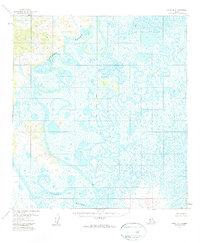
1954 Map of Ophir A-6
USGS Topo · Published 1960About this map
The Innoko River winds through this interior Alaskan wilderness, forming complex oxbows and meanders across a landscape defined by expansive wetlands. This 1954 survey captures the vast swamp systems where the Iditarod River also flows, showcasing the intricate hydrology of the region before any modern infrastructure altered the drainage patterns. Based on aerial photography from the mid-1950s, the map reveals a terrain primarily managed by the Bureau of Land Management, where the only human-marked elevation point of note is Vabm Rocky 95. The surveyor's notes regarding the Kateel River Meridian and the absence of established roads or trails underscore the remote nature of this riverine environment during the mid-twentieth century.
Find a feature on this map
4 named features on this map. Tap any name to fly to it.
Don’t see what you’re looking for? This feature index may not catch every label — zoom into the map to look around manually.
Map Details
Editions of this 1954 Ophir A-6 Map
2 editions found
Other maps of this area

1951 · Ophir
USGS Topo · 1:250,000

1951 · Unalakleet
USGS Topo · 1:250,000

1951 · Holy Cross
USGS Topo · 1:250,000

1951 · Iditarod
USGS Topo · 1:250,000

1952 · Unalakleet A-1
USGS Topo · 1:63,360

1952 · Holy Cross D-1
USGS Topo · 1:63,360

1952 · Unalakleet B-1
USGS Topo · 1:63,360

1952 · Unalakleet
USGS Topo · 1:250,000

1952 · Holy Cross
USGS Topo · 1:250,000

1954 · Iditarod D-6
USGS Topo · 1:63,360