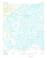
1954 Map of Ophir A-6
USGS Topo · Published 1960About this map
Innoko River and Iditarod River dominate this low-lying Alaskan landscape, their meandering courses creating a complex network of oxbow lakes and wetlands. The terrain is characterized by a dense pattern of water bodies and marshland, highlighting the dynamic hydrology of the Yukon-Koyukuk region before any modern infrastructure altered the drainage. The Kateel River Meridian bisects the area, serving as a primary surveying reference for this remote wilderness. Aside from the natural water features, the landscape remains largely devoid of named settlements, with only the VABM Rod benchmark providing a fixed point of triangulation for early mappers. This map illustrates the intricate, shifting nature of subarctic river systems in an era when aerial photogrammetry was first being used to document the interior's vast, roadless expanses.
Find a feature on this map
4 named features on this map. Tap any name to fly to it.
Don’t see what you’re looking for? This feature index may not catch every label — zoom into the map to look around manually.
Map Details
Editions of this 1954 Ophir A-6 Map
2 editions found
Other maps of this area

1951 · Ophir
USGS Topo · 1:250,000

1951 · Unalakleet
USGS Topo · 1:250,000

1951 · Holy Cross
USGS Topo · 1:250,000

1951 · Iditarod
USGS Topo · 1:250,000

1952 · Unalakleet A-1
USGS Topo · 1:63,360

1952 · Holy Cross D-1
USGS Topo · 1:63,360

1952 · Unalakleet B-1
USGS Topo · 1:63,360

1952 · Unalakleet
USGS Topo · 1:250,000

1952 · Holy Cross
USGS Topo · 1:250,000

1954 · Ophir A-6
USGS Topo · 1:63,360