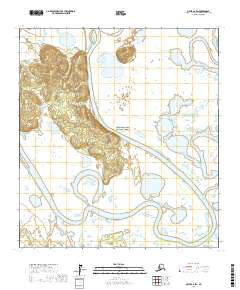
2017 Map of Ophir A-6 SW
USGS Topo · Published 2017About this map
The Innoko River winds through this interior Alaskan wilderness, defining a landscape of complex wetlands and meandering waterways within the Innoko National Wildlife Refuge. This 2017 survey captures the intricate river systems where the Iditarod River and Netletna River intersect with the broader Innoko basin. The terrain is characterized by oxbow lakes and shifting fluvial patterns, illustrating the dynamic nature of the Yukon-Koyukuk region. Mapping of these remote corridors provides critical spatial data for understanding the hydrology of the Innoko flats, an area dominated by seasonal water movement and a lack of permanent human settlements or road infrastructure.
Find a feature on this map
13 named features on this map. Tap any name to fly to it.
Don’t see what you’re looking for? This feature index may not catch every label — zoom into the map to look around manually.
Map Details
Editions of this 2017 Ophir A-6 SW Map
This is the sole edition of this map. No revisions or reprints were ever made.
Other maps of this area

1951 · Ophir
USGS Topo · 1:250,000

1951 · Unalakleet
USGS Topo · 1:250,000

1951 · Holy Cross
USGS Topo · 1:250,000

1951 · Iditarod
USGS Topo · 1:250,000

1952 · Unalakleet A-1
USGS Topo · 1:63,360

1952 · Holy Cross D-1
USGS Topo · 1:63,360

1952 · Unalakleet
USGS Topo · 1:250,000

1952 · Holy Cross
USGS Topo · 1:250,000

1954 · Ophir A-6
USGS Topo · 1:63,360

1954 · Iditarod D-6
USGS Topo · 1:63,360