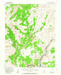
1953 Map of Orange Cliffs
USGS Topo · Published 1964About this map
Orange Cliffs define the edge of a high plateau in this mid-century survey, looking down into the intricate sandstone canyons of the Green and Colorado River systems. The map shows the region just as the waters of Lake Powell were projected to rise, with blue hatching indicating areas destined to be submerged at an elevation of 3700 feet. This creates a fascinating record of the original riverbank features along Cataract Canyon, including several named rapids. Deep in the backcountry, the landscape is marked by isolated landmarks like Teapot Rock, The Hat, and the transition from Gordon Flats to the complex erosion of The Maze. Local history and geography enthusiasts can trace the early jeep trails and a remote landing strip on Flint Flat that provided some of the only access to this labyrinthine terrain.
Find a feature on this map
69 named features on this map. Tap any name to fly to it.
Don’t see what you’re looking for? This feature index may not catch every label — zoom into the map to look around manually.
Map Details
Editions of this 1953 Orange Cliffs Map
3 editions found

Other maps of this area

1885 · San Rafael
USGS Topo · 1:250,000

1885 · La Sal
USGS Topo · 1:250,000

1886 · Henry Mountains
USGS Topo · 1:250,000

1886 · Abajo
USGS Topo · 1:250,000

1892 · Abajo
USGS Topo · 1:250,000

1892 · Henry Mountains
USGS Topo · 1:250,000

1893 · Abajo
USGS Topo · 1:250,000

1935 · Elk Ridge
USGS Topo · 1:96,000

1940 · Elk Ridge
USGS Topo · 1:125,000

1951 · Upheaval Dome
USGS Topo · 1:62,500