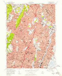
1955 Map of Orange
USGS Topo · Published 1958About this map
Watchung Mountain and its prominent ridges shape the residential and institutional landscape of northern New Jersey in the mid-1950s. The area is characterized by a dense network of suburban settlements such as Montclair, Bloomfield, and West Orange, alongside massive public works and healthcare complexes including the Overbrook Hospital, the County Sanatorium, and the County Isolation Hospital. These institutions represent a specific era of public health infrastructure situated on the higher elevations of the Second Watchung Mountain.
Find a feature on this map
163 named features on this map. Tap any name to fly to it.
Don’t see what you’re looking for? This feature index may not catch every label — zoom into the map to look around manually.
Map Details
Editions of this 1955 Orange Map
4 editions found
Other maps of this area

1888 · Plainfield
USGS Topo · 1:62,500

1888 · Morristown
USGS Topo · 1:62,500

1888 · Paterson
USGS Topo · 1:62,500

1892 · Paterson
USGS Topo · 1:62,500

1893 · Plainfield
USGS Topo · 1:62,500

1894 · Morristown
USGS Topo · 1:62,500

1898 · Morristown
USGS Topo · 1:62,500

1898 · Plainfield
USGS Topo · 1:62,500

1898 · Staten Island
USGS Topo · 1:62,500

1898 · Paterson
USGS Topo · 1:62,500