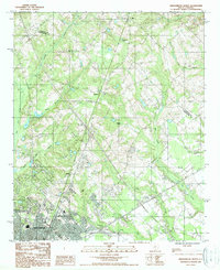
1987 Map of Orangeburg North
USGS Topo · Published 1988About this map
Orangeburg anchors the southern portion of this landscape, where urban infrastructure meets the intricate wetland networks of the South Carolina Coastal Plain. Compiled from 1981 aerial photography, the map reveals a transition from the city's outskirts to rural settlements like Jamison and Fersners. The terrain is heavily defined by hydrologic features, most notably the meandering paths of Four Hole Swamp, Bull Swamp, and Caw Caw Swamp.
Find a feature on this map
24 named features on this map. Tap any name to fly to it.
Don’t see what you’re looking for? This feature index may not catch every label — zoom into the map to look around manually.
Map Details
Editions of this 1987 Orangeburg North Map
This is the sole edition of this map. No revisions or reprints were ever made.
Other maps of this area

1920 · Bowman
USGS Topo · 1:48,000

1920 · Orangeburg
USGS Topo · 1:48,000

1921 · Orangeburg
USGS Topo · 1:62,500

1921 · Bowman
USGS Topo · 1:62,500

1943 · Bowman
USGS Topo · 1:62,500

1943 · Orangeburg
USGS Topo · 1:125,000

1943 · Orangeburg
USGS Topo · 1:62,500

1946 · Elloree
USGS Topo · 1:62,500

1946 · St. Matthews
USGS Topo · 1:62,500

1954 · Augusta
USGS Topo · 1:250,000