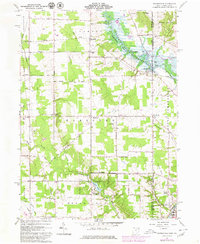
1961 Map of Orangeville
USGS Topo · Published 1980About this map
The Shenango River Reservoir dominates the northeastern landscape of this Trumbull County region, where the state line with Pennsylvania forms a sharp divide between the communities of Orangeville and South Pymatuning. During this mid-century period, the area maintained a rural industrial character, evidenced by a Quarry and Borrow Pit near Hartford. The Conrail rail lines intersect the landscape, connecting small hubs like Latimer and Burghill to the larger industrial center of Sharon to the southeast. Local history is deeply embedded in the terrain through family and community landmarks such as Artherholt Cem, St Marys Cemetery, and the Sharon Speedway, which sits just east of the village of Hartford. This survey captures the transition of the local economy from strictly agricultural pursuits toward modern recreation and regional transport networks.
Find a feature on this map
46 named features on this map. Tap any name to fly to it.
Don’t see what you’re looking for? This feature index may not catch every label — zoom into the map to look around manually.
Map Details
Editions of this 1961 Orangeville Map
4 editions found
Other maps of this area

1905 · Neshannock
USGS Topo · 1:62,500

1906 · Youngstown
USGS Topo · 1:62,500

1907 · Neshannock
USGS Topo · 1:62,500

1907 · Kinsman
USGS Topo · 1:62,500

1908 · Shenango
USGS Topo · 1:62,500

1908 · Youngstown
USGS Topo · 1:62,500

1950 · Cleveland
USGS Topo · 1:250,000

1954 · Sharon West
USGS Topo · 1:24,000

1954 · Girard
USGS Topo · 1:24,000

1956 · Cleveland
USGS Topo · 1:250,000