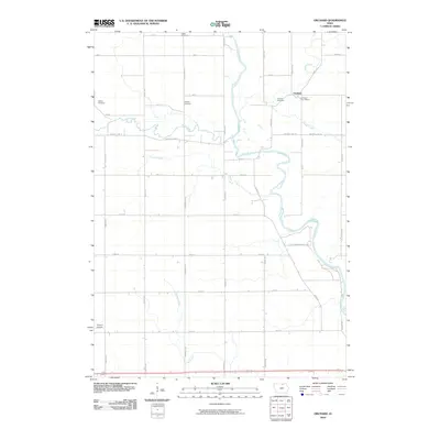
2010 Map of Orchard
USGS Topo · Published 2010About this map
The Cedar River meanders through this portion of Mitchell County, defining a landscape shaped by its many tributaries and a well-ordered grid of agricultural roads. The small settlement of Orchard serves as a central hub, anchored by the Orchard Post Office and nearby Orchard Cemetery. This survey reveals a high density of burial grounds relative to the population centers, including the Tucker Cemetery, Dudley Cemetery, and Calvary Cemetery, which provide essential points of reference for genealogists tracking local family histories.
Find a feature on this map
39 named features on this map. Tap any name to fly to it.
Don’t see what you’re looking for? This feature index may not catch every label — zoom into the map to look around manually.
Map Details
Editions of this 2010 Orchard Map
This is the sole edition of this map. No revisions or reprints were ever made.
Other maps of this area

1954 · Mason City
USGS Topo · 1:250,000

1957 · Mason City
USGS Topo · 1:250,000

1958 · Mason City
USGS Topo · 1:250,000

1971 · Rockford
USGS Topo · 1:24,000

1971 · Orchard
USGS Topo · 1:24,000

1971 · Rudd
USGS Topo · 1:24,000

1971 · Charles City
USGS Topo · 1:24,000

1971 · Floyd
USGS Topo · 1:24,000
1971 · Roseville
USGS Topo · 1:24,000

1972 · Osage
USGS Topo · 1:24,000