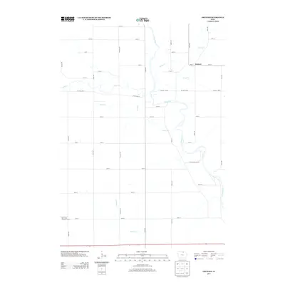
2013 Map of Orchard
USGS Topo · Published 2013About this map
The settlement of Orchard is the primary focal point of this northern Iowa landscape, situated where Spring Cr and Slough Cr approach the meandering Cedar River. The terrain is defined by a grid of agricultural section lines and several small waterways, including Rock Cr, Sunken Cr, and Stewart Cr, which carve through the farmland. In the southern portion of the quadrangle, Spirit Lake Municipal Airport serves as a notable regional landmark. The map illustrates a developed network of rural infrastructure, from the industrial Quarry Rd to the recreational area near Cedar Springs Camp Rd. This survey documents the intersection of rural Mitchell County life and the natural hydrology of the Cedar River valley during the early 21st century.
Find a feature on this map
36 named features on this map. Tap any name to fly to it.
Don’t see what you’re looking for? This feature index may not catch every label — zoom into the map to look around manually.
Map Details
Editions of this 2013 Orchard Map
This is the sole edition of this map. No revisions or reprints were ever made.
Other maps of this area

1954 · Mason City
USGS Topo · 1:250,000

1957 · Mason City
USGS Topo · 1:250,000

1958 · Mason City
USGS Topo · 1:250,000

1971 · Rockford
USGS Topo · 1:24,000

1971 · Orchard
USGS Topo · 1:24,000

1971 · Rudd
USGS Topo · 1:24,000

1971 · Charles City
USGS Topo · 1:24,000

1971 · Floyd
USGS Topo · 1:24,000
1971 · Roseville
USGS Topo · 1:24,000

1972 · Osage
USGS Topo · 1:24,000