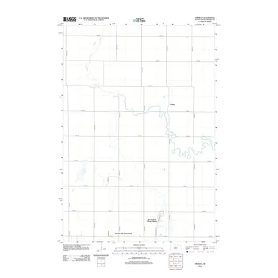
2012 Map of Ordway
USGS Topo · Published 2012About this map
Elm River meanders sharply across this portion of Brown County, defining the rural landscape north of Aberdeen. The small settlement of Ordway sits near the river's bend, positioned at the intersection of a grid-iron road system that includes 125th St and 391st Ave. This early 21st-century survey reveals the encroaching residential expansion from the south, evidenced by the Prairie Wood Village Addition and the Deevaan Villa Development. These subdivisions represent a modern shift in land use, contrasting with the more isolated Alkali Lake and the vast agricultural tracts that dominate the northern half of the quadrangle. The map captures a moment when traditional Great Plains farmstead patterns began to meet organized suburban planning along corridors like Prairiewood Dr and Ironwood Dr.
Find a feature on this map
24 named features on this map. Tap any name to fly to it.
Don’t see what you’re looking for? This feature index may not catch every label — zoom into the map to look around manually.
Map Details
Editions of this 2012 Ordway Map
This is the sole edition of this map. No revisions or reprints were ever made.
Other maps of this area

1894 · Columbia
USGS Topo · 1:62,500

1895 · Aberdeen
USGS Topo · 1:125,000

1896 · Columbia
USGS Topo · 1:125,000

1899 · Ellendale
USGS Topo · 1:125,000

1899 · Northville
USGS Topo · 1:125,000

1952 · Columbia
USGS Topo · 1:24,000

1952 · Ordway
USGS Topo · 1:24,000

1952 · Columbia NE
USGS Topo · 1:24,000

1952 · Westport
USGS Topo · 1:24,000

1952 · Richmond NE
USGS Topo · 1:24,000
Featured Places
- Aberdeen, SD
- Ordway, SD
- Prairie Wood Village Addition, SD
- Lincoln Township, SD
- Deevaan Villa Development, SD